Tuesday, 21 June 2016

The Ancient Welwitschia Plant


Welwitschia mirabilis, one of the three wonders of the Plant Kingdom, can be found in central Namibia, which is its southernmost distribution limit.  The Welwitschia plant can grow to be over 1,000 years old with recent carbon tests have indicated ages up to 5,000 years.


The plant only forms two leaves, which continuously grow from the base, while the ends die off and wither.


Welwitschias usually grow in washes and along lines of water runoff. Here soil moisture accumulates from rare rainfall events and becomes trapped in coarse gravel or between rock fissures. 

The plant tap this ground moisture with their large lateral root system, which can reach a radius of about 15 metres from the plant, but rarely penetrates the soil deeper than 2 metres


                                           Younger female plant with seed cones.

Monday, 20 June 2016

Swakopmund Namibia.

February 15, 2016

We were en route to Swakopmund and small self-sustained villages started to appear along the coastline. 

It was a three-day rest stop for the crew that accommodated us on our journey and a break from camping for us. The break gave us an opportunity to explore the town and its surrounding. 

Swakopmund has a German history and its location 280km west of Windhoek, the capital of Namibia and it is on the edge of the Namib dessert.  It is at the mouth of the Swakopriver, and it is a beach resort with German colonial architecture. 

It was founded in 1892 as the main harbour for the Imperial German colony and one of the few sources of fresh water in the area. 

Most very town has a war memorial, and this one is known as Marine Denkmal, a Marine Memorial. This dramatic sculpture depicts the defeat of the Hereros at Otjimbingwe by a troop of German Marines.
The German death toll at the time was only one, followed by later skirmish and losing another.  With street names changing from Kaiser Wilhelm Strasse to Sam Nujoma Avenue and  Schlosser Strasse to Mandume Ya Ndemufayo Street, it is only a matter of time before erecting a statue honouring the Hereros who have perished.

The still operational lighthouse’s beacon can be seen as far 35 nautical miles from the sea. The lighthouse is a major landmark of the Swakopmund skyline. The old lighthouse keepers accommodation is now a Restaurant and Pub.

Brad Pitt and Angelina Jolie decided to have their baby in Namibia, which is not readily available to the hordes of paparazzi. Their daughter Shiloh Jolie-Pitt was born on May 27, 2006, at a small hospital near Swakopmund. 

Sunday, 19 June 2016

Cape Cross Seal Reserve


Not far from Cape Cross is the Cape Cross Seal Reserve and also the largest breeding colony of Cape fur seals in the world. 


This barren and inhospitable coastline laid unexplored for 400 years after Diego Cão in 1486 erected the stone cross.


The first sighting of the seals was in 1884 of the coast of Southern Africa. During that period, the world had an interest in guano, the waste left by fish-eating birds and was using it as fertiliser and it didn’t take long before discovering this coast. In 1895, people started to settle in Cape Cross and the guano export business boomed. The first railway line and water distilling plant were built along with a post office. 


The boom was short-lived, and nine years later the harsh nature of the coast one again reclaimed the land; the harbour became a salt pan, and the rusty remains of the guano industry lay hidden in the sand.


The Reserve lies close to the town of Swakopmund and Henries Bay within the West Coast National Park, a 200 stretch of coastline between the Swakop and Ugab rivers. The Brandberg Mountain is visible from Cape Cross.


From a distance, thousands of seals contribute to the cacophony of bleats and barks that fill the air competing with the screeching of Kelp gulls. 


During the breeding season in November and December, there may be up to 210,000 seals at Cape Cross.


The 200-metre walkway constructed of recycled plastic keep a safe distance between visitors and seals. 


The cold Benguela Current hold thousands of pups amused in the water learning their fishing skills and also the awareness of sharing the waters with Killer whales and Copper sharks. 


On land, the black-backed jackal prowl the edge of the colony and at night the elusive brown hyena awaits the right opportunity.


                We waived goodbye to sweet pups as we continue out journey to Swakopmund.

Saturday, 18 June 2016

The Skeleton Coast


The Atlantic Ocean side of Namibia is known as the Skeleton Coast. The name Skeleton Coast was invented by John Henry Marsh, as the title for his book he wrote chronicling the shipwreck of the Dunedin Star. After the publication of the book in 1944, it became so well known that it now generally referred to as the Skeleton Coast National Park. 


The park stretches from the Kunene River to the north for approximately 500km to the Ugab River in the south and protects about one-third of the Namibia’s coastline. 


There are the remnants of ocean liners, trawlers, galleons, clippers and gunboats buried deep into the sand. The best way viewing them would be by air. Sand, salt pan and arid mountains stretch inland for hundreds of miles with little water or substances of any kind. 


The landscape includes dunes, canyons and mountain ranges all of which are synonymous with Namibia. 


The Portuguese navigator and explorer Diogo Cão, under orders of King João II, was to discover regions along the west coast of Africa. During his second voyage, Cäo reached Cape Cross in 1486, the first European to visit the area and two years before Bartholomeu Dias successfully rounded Cape of Good Hope. 


The original Cape Cross was removed by the commander of the German Navy and taken to Berlin.The inscription on the cross reads, in English translation “In the year 6685 after the creation of the world and 1485 after the birth of Christ, the brilliant, far-sighted King John II of Portugal, ordered Diogo Cão, knight of the court, to discover this land and to erect this padrão here”
.

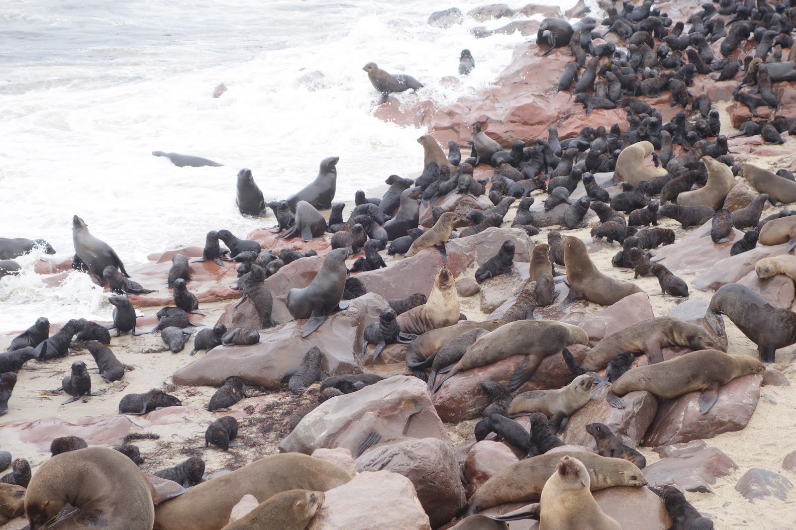
Today Cape Cross is a protected area under the name of Cape Cross Seal Reserve. The reserve is a home to the largest Cape fur seals in the world.


Mining is the biggest contributor to Namibia’s economy, and the majority of its revenue comes from diamond mining.  Interesting rocks and minerals can be picked up around in mines, quarries, ocean cliffs, beaches, riverbanks and road cuts.


Thursday, 16 June 2016

The White Lady of Brandberg


Reinhard Maack rendering of the White Lady

Brandenburg Massif lies about 100km away from Spitzkoppe and hosts over 1000 bushman paintings scattered in caves and rock shelves. The most famous and intriguing are the image of the White Lady. The Brandberg is also Namibia's highest mountain. 


The painting has long been an archaeological dilemma and several different hypotheses have been put forth to its origins, authorship and dating. It is now accepted to be a bushman painting dating back at least 2000 years


In 1917 topographer Reinhardt Maack and Alfred Hoffmann, a cartographer were surveying the Brandberg when they took shelter for the night under an overhanging rock. On awakening, Maack saw the rock painting and made a sketch of it and added a note to his dairy. “The Egyptian Mediterranean style of all its figures is surprising.“ This statement started the myth and controversy for over half a century. 

The White Lady group is found in a cave known as “Maack Shelter” and depicts several human figures along with oryxes. The rock panel measures about 5.5m by 1.5m. And the White Lady is 39.5 cm by 29 cm.

This painting has also suffered from damages since if was first made public in the early 20th century. Decades of wetting the image on the rock face, only to get a better photograph, has caused considerable damage and cause the art to disappear more rapidly.


There have since been many other theories about her, as the White Lady is very detailed, and the assumption is that she is a medicine woman. She has white painted arms and legs or was wearing decorative attachments.


In this illustration, she has a bow in one hand and perhaps a goblet in the other running towards the oryxes.  That gives an indication that it is a hunting scene. Apart from the shaman-lady, the other figures are either completely black or white as if she was the most prominent figure in the pictograph. One of the oryxes also has human legs.

Namibian oryxes

The rock art paint is in ochre, charcoal, manganese, hematite, with blood serum, egg white and casein used as binding agents. The natural dyes and colour combination is still visible in today's basket weaving and other decors.


         The Brandberg site is a protected area and the viewing in the presence of an official guide.


Wednesday, 15 June 2016

Bushman art

February 14th, 2016

Bushman art is found throughout Southern Africa, and many examples can be seen painted on the rocks, caves, narrow passageways and overhangs,  just outside Spitzkoppe. 

Some of these 2000 to 4000-year-old prehistoric rock paintings, can still be seen. 
After their discovery and their location made public, it saw an influx of tourism in the area.  


Most, however, have been vandalised and some destroyed through time. Some pieces have removed by chiselling it from the rock face; others had been washed with water or other liquids to enhance the colouring of the now fading pictograph. 

Some have been “touched-up”, mainly to darken the image for the photographer and the exposure to the old flashbulbs had their ill effect on the already fading art. 


Lack of funding delayed the conservation of the area. The site now has a gated fence and is under the protection of the MET of Namibia with the necessary mandate to save the mountain from increasing tourism. 


The Spitzkoppe area is under the management of a woman’s cooperative who maintain campsites as it has now become a traditional mountaineering, camping and hiking destination. There are local guides who will take you on a walking tour of the Bushman art and among the remnants of this ancient volcano.


Tuesday, 14 June 2016

Spitzkoppe, Namibia


February 14th


Located in former German South West Africa, its name meaning “sharp head” and is North-east of Swakopmund and close to Usakos. The imposing granite rock formation is more than 120 million years old and the highest outcrop rises about 1,784 metres above sea level. 


Due to its location, there is otherwise little known about the history of this rock formation. The records show that the first scaling of the rock was in 1946. 


Damaraland was the name given to this area and later became part of Namibia. In 1970 they moved multiple Damara families here, which has a village with both a school and a church. There are some forgotten graves of German settlers visible in the area.


The scenery changed from an orange hued oil painting to a soft watercolour and the sunset spectacular from the top of the rock.

                                                                                 
From above I could see our truck and could also spot the campsite I was going to take for the night and there was plenty of room for everyone. 


The area has been hunted and depleted of its game in the past along with the harshness of the savanna not easily replenishable.  The park is reintroducing several species of buck, Zebra and Leopards which previously roamed the area.


The night sky was clear with a brilliant showing of stars followed.

Many examples of Bushman artwork can be seen painted on the rock a short distance from here.